Distance from Clopper, Maryland to Redland, Maryland
The driving distance from Clopper, Maryland to Redland, Maryland is 8 mi (12.8 km)
The straight-line (air) distance is approximately 3.3 mi (5.3 km)
Estimated travel time by road is 14 minutes
We found 3 routes between Clopper and Redland.
Available Routes
Route Directions
Take Game Preserve Rd to MD-117 E
Continue on MD-117 E. Take Exit 9, I-370 E and Shady Grove Rd to Mill Run Dr in Redland
Continue on Mill Run Dr. Drive to Redland Rd
Route Directions
Follow Game Preserve Rd to Frederick Rd
Follow MD-124 N and Midcounty Hwy to Mill Run Dr in Redland
Continue on Mill Run Dr. Drive to Redland Rd
Route Directions
Take Game Preserve Rd to MD-117 E/Clopper Rd
Continue on MD-117 E/Clopper Rd. Take MD-124 N and Midcounty Hwy to Mill Run Dr in Redland
Continue on Mill Run Dr. Drive to Redland Rd
Journey Details
Traveling from Clopper, Maryland to Redland, Maryland covers 6.9 miles (11 km) in a east direction. This local streets, short route typically takes 18 minutes under normal conditions.
Drivers have 3 route options between these locations (7-8 miles / 11-13 km). The primary route shown here saves 36 seconds compared to alternatives.
The route features scenic views. During night weekday travel, expect minimal traffic congestion with average speeds around 20 mph (32 km/h) .
Journey Waypoints
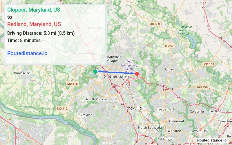
Clopper
Starting Point
Redland
Destination
Route Map Image