Distance to Lennep, Montana

Calculating Your Route
Just a moment while we process your request...
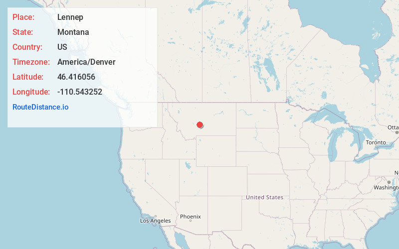
Location Information
-
Full AddressLennep, MT 59053
-
Coordinates46.416056, -110.5432522
-
LocationLennep , Montana , US
-
TimezoneAmerica/Denver
-
Current Local Time5:39:49 PM America/DenverThursday, June 19, 2025
-
Page Views0
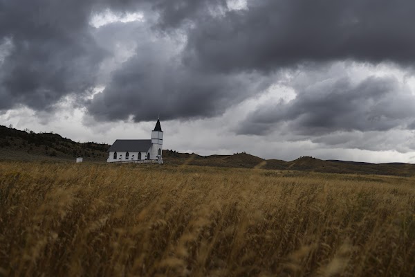
About Lennep
Lennep is a ghost town and populated place in Meagher County, Montana, United States.
Lennep has a still-active Lutheran church, and 3 inhabited houses. Closed buildings include a two-story general store/post office, and a K-8 school.

Nearby Places
Found 10 places within 50 miles

Groveland
7.1 mi
11.4 km
Groveland, MT 59053
Get directions
Loweth
8.5 mi
13.7 km
Loweth, MT 59053
Get directions
Martinsdale Colony
14.1 mi
22.7 km
Martinsdale Colony, MT 59053
Get directions
Moyne
19.3 mi
31.1 km
Moyne, MT 59645
Get directions

White Sulphur Springs
19.4 mi
31.2 km
White Sulphur Springs, MT 59645
Get directions
Springdale Colony
22.7 mi
36.5 km
Springdale Colony, MT 59645
Get directions
Duncan Ranch Colony
24.8 mi
39.9 km
Duncan Ranch Colony, MT 59085
Get directions

Wilsall
29.7 mi
47.8 km
Wilsall, MT 59086
Get directions

Harlowton
33.8 mi
54.4 km
Harlowton, MT 59036
Get directions
Sedan
34.9 mi
56.2 km
Sedan, MT
Get directions
Location Links
Local Weather
Weather Information
Coming soon!
Location Map
Static map view of Lennep, Montana
Browse Places by Distance
Places within specific distances from Lennep
Short Distances
Long Distances
Click any distance to see all places within that range from Lennep. Distances shown in miles (1 mile ≈ 1.61 kilometers).