Distance from Devol, Oklahoma to Sneed Acres, Oklahoma
The driving distance from Devol, Oklahoma to Sneed Acres, Oklahoma is 47.5 mi (76.4 km)
The straight-line (air) distance is approximately 20.2 mi (32.5 km)
Estimated travel time by road is 48 minutes
This route includes Toll roads along the way.
We found 2 routes between Devol and Sneed Acres.
Available Routes
Route Directions
Take OK-36 S and I-44 E to NE Rogers Ln in Lawton. Take exit 40B from I-44 E
Take Indian Trail Rd to NW Morningside Dr
Route Directions
Get on I-44 E
Follow I-44 E to NE Rogers Ln in Lawton. Take exit 40B from I-44 E
Take Indian Trail Rd to NW Morningside Dr
Journey Details
Traveling from Devol, Oklahoma to Sneed Acres, Oklahoma covers 41.2 miles (66 km) in a northeast direction. This mixed highways and local roads, moderate route typically takes 38 minutes under normal conditions.
Drivers have 2 route options between these locations (41-47 miles / 66-76 km). The primary route shown here saves 10 minutes compared to alternatives.
The route features scenic views, toll sections. During night weekday travel, expect minimal traffic congestion with average speeds around 49 mph (79 km/h) .
Journey Waypoints
Devol
Starting Point
Sneed Acres
Destination
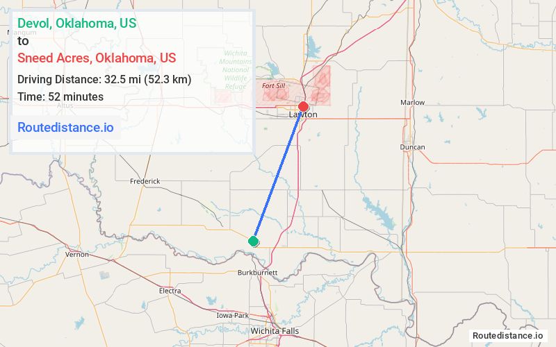
Route Map Image