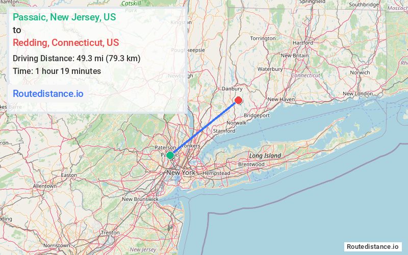
Distance from Passaic, New Jersey to Redding, Connecticut
The driving distance from Passaic, New Jersey to Redding, Connecticut is 76.9 mi (123.8 km)
The straight-line (air) distance is approximately 30.6 mi (49.3 km)
Estimated travel time by road is 1 hour 28 minutes
This route includes Toll roads along the way.
We found 3 routes between Passaic and Redding.
Available Routes
Route Directions
Get on Garden State Pkwy N in Elmwood Park from NJ-21 N and US-46 E
Continue on Garden State Pkwy N. Take I-287 E and CT-15 N to CT-57 N/Weston Rd in Westport. Take exit 42 from CT-15 N
Follow CT-57 N/Weston Rd and CT-53 N to Old Stagecoach Rd in Redding
Route Directions
Get on I-80 E from NJ-21 N
Continue on I-80 E. Take I-87 N, Cross County Pkwy, Hutchinson Riv Pkwy N and CT-15 N to CT-57 N/Weston Rd in Westport. Take exit 42 from CT-15 N
Follow CT-57 N/Weston Rd and CT-53 N to Old Stagecoach Rd in Redding
Route Directions
Get on I-80 E from NJ-21 N
Take I-80 Express E, I-87 N, Cross County Pkwy, Hutchinson Riv Pkwy N and CT-15 N to CT-57 N/Weston Rd in Westport. Take exit 42 from CT-15 N
Follow CT-57 N/Weston Rd and CT-53 N to Old Stagecoach Rd in Redding
Journey Details
Traveling from Passaic, New Jersey to Redding, Connecticut covers 72.5 miles (117 km) in a northeast direction. This mixed highways and local roads, substantial route typically takes 1 hour 29 minutes under normal conditions.
Drivers have 3 route options between these locations (73-77 miles / 117-124 km). The primary route shown here saves 12 seconds compared to alternatives.
The route features toll sections. During midday weekend travel, expect typical weekend traffic patterns with average speeds around 52 mph (84 km/h) .
Journey Waypoints
Passaic
Starting Point
Redding
Destination
Route Map Image