Distance to Red Rock, Texas

Calculating Your Route
Just a moment while we process your request...
Location Information
-
Full AddressRed Rock, TX 78662
-
Coordinates29.9596656, -97.4461058
-
LocationRed Rock , Texas , US
-
TimezoneAmerica/Chicago
-
Current Local Time5:50:04 PM America/ChicagoMonday, June 23, 2025
-
Page Views0
About Red Rock
Red Rock is an unincorporated community in Bastrop County, Texas, United States.


Nearby Places
Found 10 places within 50 miles

Rosanky
9.4 mi
15.1 km
Rosanky, TX
Get directions

Cedar Creek
9.4 mi
15.1 km
Cedar Creek, TX
Get directions
Wyldwood
11.8 mi
19.0 km
Wyldwood, TX
Get directions

Bastrop
13.0 mi
20.9 km
Bastrop, TX 78602
Get directions

Lockhart
14.4 mi
23.2 km
Lockhart, TX 78644
Get directions

Mustang Ridge
16.1 mi
25.9 km
Mustang Ridge, TX
Get directions

Garfield
17.1 mi
27.5 km
Garfield, TX
Get directions

Niederwald
17.2 mi
27.7 km
Niederwald, TX
Get directions

Smithville
17.5 mi
28.2 km
Smithville, TX 78957
Get directions

Camp Swift
18.4 mi
29.6 km
Camp Swift, TX 78602
Get directions
Location Links
Local Weather
Weather Information
Coming soon!
Location Map
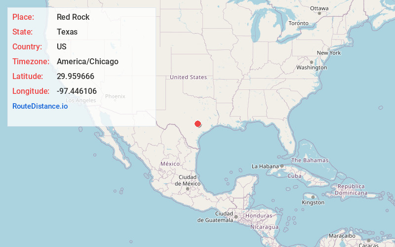
Static map view of Red Rock, Texas
Browse Places by Distance
Places within specific distances from Red Rock
Short Distances
Long Distances
Click any distance to see all places within that range from Red Rock. Distances shown in miles (1 mile ≈ 1.61 kilometers).