Distance to Ashland, Tennessee

Calculating Your Route
Just a moment while we process your request...
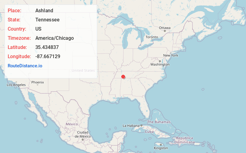
Location Information
-
Full AddressAshland, TN 38485
-
Coordinates35.434837, -87.667129
-
LocationAshland , Tennessee , US
-
TimezoneAmerica/Chicago
-
Current Local Time2:18:55 PM America/ChicagoMonday, May 19, 2025
-
Page Views0
About Ashland
Ashland is an unincorporated community located in Wayne County, Tennessee, United States.
Nearby Places
Found 10 places within 50 miles

Voorhies
6.0 mi
9.7 km
Voorhies, TN 38462
Get directions

Waynesboro
9.6 mi
15.4 km
Waynesboro, TN 38485
Get directions
Lomax Crossroads
9.8 mi
15.8 km
Lomax Crossroads, Hohenwald, TN 38462
Get directions

Hohenwald
10.1 mi
16.3 km
Hohenwald, TN 38462
Get directions
Sugar Hill
11.8 mi
19.0 km
Sugar Hill, TN 37096
Get directions
Mooney
12.9 mi
20.8 km
Mooney, TN 38425
Get directions
Henryville
15.6 mi
25.1 km
Henryville, TN 38464
Get directions
Chestnut Grove
15.7 mi
25.3 km
Chestnut Grove, TN 37096
Get directions


Leaflet © OpenStreetMap contributors
Location Links
Local Weather
Weather Information
Coming soon!
Location Map
Static map view of Ashland, Tennessee
Browse Places by Distance
Places within specific distances from Ashland
Short Distances
Long Distances
Click any distance to see all places within that range from Ashland. Distances shown in miles (1 mile ≈ 1.61 kilometers).